Saturday, December 29, 2012

Finding the Trail Head

There's plenty of human-erected treasures to search for on Yakushima:

Seven statues of the Fortune God. . . .Countless small shrines to Ebisu. . . .Village plaques. . . .Trail heads.

Yeh, trail heads.

I mentioned before on my facebook page that I'd like to visit all the mountain-peak shrines in Yakushima. Most of these are on the lower Exterior Mountains and require only a two to three hour hike from the trail head.

Finding the trail heads, however, is the real challenge. Beyond the major routes in books and tourist maps (i.e. the regularly-maintained trails to places like Mt. Miyanoura and Jomon Sugi, places that require nothing more than physical preparation), it's not obvious how many of these old trails are still in use, where they begin, and if whether or not they've just disappeared into the brush. To make matters ten times more complicated, it turns out even the latest maps of Yakushima have some number of phantom back-roads. And the roads that do exist may be half-washed away or blocked by gates for various reasons.

Through a mix of GPS, asking for directions, and trial and error, any day you find a new, legitimate trail head is a good day. Today was one of those days, and that's why I leave you with a picture of a (genuine, Yakushima) cow.

This is not the way to the trail head.

Thursday, December 13, 2012

Hananoego Trail: A deep forest trek


After hiking most of the other major trails, I finally did the less-popular Hananoego Trail last week. This is a gorgeous trail that meanders up and down for 8.4 km from the far end of the Yakusugiland Park, to Hananoego, the high-altitude peat marsh.

The trail splits off into the deep forest halfway along the 150-min Yakusugiland course. Almost immediately, I lose my sense of direction and begin to feel a vague sense of isolation. I remember reading somewhere that the Hananoego Trail was originally staked out for a national foot race, and, although I have my doubts about that, it certainly requires a bit of sweat and perseverance to follow this trail until it finally reaches a forest ridge walk. This is only major trail that has taken me nearly full map-time to walk (6-7 hours from the parking lot at Yakusugiland to Hananoego, where the Hananoego Trail meets the Yodogawa Trail. ).


Yamato Sugi
est. age: 3,000-4,000 yrs


About 90 minutes after leaving Yakusugiland, signs lead down a short path to Yamato Sugi. This cryptomeria is over 10 meters around, nearly 30 meters tall, and has an estimated age of 3,000-4,000 years.

Stream/River Crossing


There's one beautiful stream-crossing (a tributary of the Anbo River), so check for weather-warnings if you do this trail.

View from Mihirashi Observation Point.
Today, a band of clouds obscured the
peaks of the Interior Mountains.


Although this trail doesn't lead to a mountain peak, it does have one rocky outlook, which you can use a rope to climb up. This is the first spot where I was finally able to get a sense of location. You can see across to the highest Interior Mountains, and also "Tofu Rock" beyond Hananoego (not in my picture).

Ishizua Hut. They say it's haunted.

Finally, the trail leads to Ishizua Hut. This hut is very clean inside, and big enough to hold twenty people, although it's usually rather quite. Of course, there is a stream nearby for water, and a toilet, but at 1580 meters nights are cold, and some people say it's haunted. . .

Remains of a shelter at Hananoego.
Within an hour of leaving Ishizuka Hut, I reach Hananoego, one of my favorite places. There are the remains of an old, collapsed shelter, and a very welcoming bench . . .
Here, the trail ends, and I take the Yodogawa trail to get back to the road. The Yodogawa trail follows a short boardwalk through the Hananoego peat marsh before turning back into the forest. The peat is as old as 2,600 years, and there is often a variety of flowers depending on the season.


Beautiful Yodogawa River


The forest is thick with giant cryptomeria, fur, and spruce trees disappearing into the mist. A bridge crosses over the calm, emerald Yodogawa River just before the spacious Yodogawa Hut (much more popular than the Ishzuka Hut!), and I know my hike is almost over . . .


. . . Except that when I reach the Yodogawa Trailhead I still have 7.5km of asphalt between me and my car. But at least it's downhill!

I think that return route down the asphalt street is main turn-off of the Hananoego Trail, but this trail is really too long to do a round-trip in a day without following the street back, and too short to split into two days.

So, I guess the Hananoego Trail is best for folks who want a good, long, rough hike through the woods, because this trail is just as demanding as hiking to a mountain peak, except that there's no peak to look forward to. Also, it's not entirely impossible to get lost on this trail, since it sees so little traffic. But, as one of several routes to Hananoego, it can serve as a gateway to the Interior Mountains, and if you're looking for more moss than people, this is a beautiful route!


Thursday, November 29, 2012

Allure of the Exterior Mountains

Gazing out from Mt. Ishidzuka
Just as hiking the Interior Mountains is an awesome experience, hiking the Exterior Mountains is a humbling experience.

Traditionally, Yakushima's mountains are divided into the Interior Mountains (Called the Oku-dake, these include the highest peaks.) and the Exterior mountains. (Called the Mae-dake, these mountains hide the Oku-dake from sight of the coastal towns.) In the past, islanders visited the Mae-dake quite frequently, but rarely approached the Oku-dake. The Oku-dake were considered the sacred realm of the gods, peaks for a select few pilgrims to visit annually. Daily needs for wood and forest products were filled from the Mae-dake.

Interior Mountains viewed
from Aiko-dake

View from Taiko Iwa . . .
bit obscured by clouds, but try
Googling images of Taiko Iwa.

Mae-dake seen from
across the valley
And then came the logging boom.

And then the tourism boom.

Now, I think, the pattern is reversed. The trails across the Oku-dake--including Mt. Miyanoura (Kyushu's highest peak), Mt. Kurio, Kuromi-Dake and a few other peaks--are well maintained and easy to follow, with wooden boards and ropes where needed. Popular trails can see hundreds of people a day.

But not so many people visit the Mae-dake. I suppose that although the trails are rougher, they just don't make for good boasting stories. The intense trail up Mt. Mocchomu. The treacherous trail up Aiko-dake. And the allure is a bit more subtle than the "360-degree ocean view" offered by Mt. Miyanoura.

Personally, though, I don't think it's possible to appreciate the grandeur of the Oku-dake without stepping back. Visitors to Shiratani-Unsuikyo's lookout from Taiko Iwa will understand what I mean. To stand on one of the eastern Mae-dake peaks and gaze across the valley at the magnificent Oku-dake is truly a humbling experience.
As if you've jumped into the middle of a deep and vast ocean, you feel incredibly small.

This sensation is ridiculously hard to capture in a picture, but if you fancy experiencing it firsthand, check the weather and do a little homework first: Not all of the Mae-dake offer views of the Oku-dake, and some clouds and fog can cover up the splendor from any peak. Also, despite being lower than the Oku-dake, they can be just as (or more!) dangerous. Taiko Iwa in Shiratani-Unsuikyo is probably the easiest way to enjoy the view I'm talking about, and--since it's located well into the interior of the island--experienced hikers can continue on to access the Oku-dake trails directly from Shiratani.

With a little help from the weather, the view of Mt. Miyanoura can be every bit as moving as the view from Mt. Miyanoura.

Saturday, November 17, 2012

Jomon Sugi in the News: Poor Health and Clone-Naming


Jomon Sugi's been in the news a couple times this month.

Folks enjoying Jomon Sugi from the observation deck.
Jomon Sugi: Possibly the oldest tree in Japan.
First the bad news: Jomon Sugi had a checkup on November 6 and failed terribly. The big branch (1-meter in diameter!) that leans out towards the observation deck is hollow near it's base and seems destined to fall, quite possibly this winter if we get much snow. Last week they posted a warning sign, and yesterday they closed the front half of the deck where people like to take pictures.

Since Jomon Sugi is hollow, it's age cannot be determined, but it may be the oldest of all sugi, possibly one of the first to grow on Yakushima after the super-volcano that buried southern Japan up through Tokyo exploded 7,300 years ago. Jomon Sugi survived Edo-logging and went undiscovered by 20th century clear-cut loggers until 1966. Surely the publicity around the discovery of this ageless tree (first called "Oh-Iwa Sugi") helped environmentalists in the fight that shut down Yakushima's logging villages in 1970.

The branch in question is right in front of the observation deck.
The front-middle branch of Jomon Sugi
is rotting and may soon fall.
But now Jomon Sugi may be killed by our ignorant love for it. Jomon Sugi's troubles started when people began trampling its roots to get close and take strips of bark or carve their initials. To restrict access, an observation deck was built and monitoring cameras were erected. (That's why most pictures show only one side of the tree.) Naturally, the view of Jomon Sugi was obstructed by brush and small trees, so these were cleared away (a ridiculously careless move, in retrospect). The soil then began to wash away, and all attempts to replace it with sand and artificial supports failed in Yakushima's incessant rain. Replacement seedlings had to be planted where the former trees and brush used to be, and a fence had to be erected to keep the deer from eating these. I'm told that before they cut down those shady trees that offered protection from the sun, Jomon Sugi used to be a darker color. But now, exposed to sunlight, the near side of the trunk has turned to its current shade of pale gray.

Back in Japan's bubble days there was even serious talk of building a cable-car up to Jomon Sugi. I imagine that would have sealed it's death.

The stump of Okina Sugi, which
fell in 2010. Could Jomon Sugi
meet a similar fate?
The first undeniable sign of trouble was a large limb--over a thousand years old!--that fell off in the winter of 2005. This is commonly blamed on the heavy snow that year, but I imagine a tree the circumference (>16m) of Jomon Sugi needs every food-making limb it has. Especially  once the core starts to rot away life becomes a battle between rot and growth. When the trunk is too hollow and frail to support the tree, it can end up like Okina Sugi, a 2,000-year-old tree that fell over in September of 2010.

Maybe an optimist could consider this as natural pruning, but two branches in ten years? . . . I'd like to think this tree could live forever, but I feel inclined to suggest you visit Jomon Sugi before it's too late.

References:


In happier news, the Yakushima Environmental and Cultural Center is hosting a competition to name twelve clones of Jomon Sugi. These were grown from the limb that fell in 2005. Send a postcard with your name, age, address, and phone number along with the clone name and reason to the Culturual center at Miyanoura 823-1, Yakushima-cho, Kumage-gun, Kagoshima-ken, 891-4205. Deadline is December 24, 2012.

Original Article:

Thursday, November 8, 2012

Fall flowers and other colors

I had the great opportunity to join a group of plant-lovers the other day. I hadn't appreciated what a treasured role Japanese plants play in Western horticulture, but now I feel really stimulated to learn all the species names and families as a way to connect with folks around the world!

Fall may bring red and gold leaves to mind, but there's quite a few flowers and fruits as well:

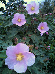
Pink: Near coastal towns, roadsides are overflowing with wild hibiscus. Since it's already November, I think this is Hibiscus makinoi (サキシマフロウ), but it could be mutabilis.


Yellow: My walk the other morning into the low, exterior mountains was also full of color. This is Yakushima and Tanegashima's endemic Ligularia Farfugium hiberniflorum (カンツワブキ).


Orange and ever-so-pale lavender and blue: The lower mountains are also home to Sarcandra glabra (left, センリョウ), an important plant for New Years; and the occasional Lasianthus fordii hance (middle/right, タシロルリミノキ), which is in the coffee family. I wonder if a hybrid could be created with blue coffee beans?


Purple and white: The endemic Tripterospermum distylum (left, ハナヤマツルリンドウ) and the endemic variety of Parnassia palustris (right, ヤクシマウメバチソウ) near Mt. Miyanoura.


Pure white:  Ainsliaea apiculata (キッコウハグマ) from the daisy family, which we passed on Mt. Eboshi last week.


Red: Winter strawberries, Rubus buergeri (left, フユイチゴ)and Japanese Rowan, Sorbus commixta (right, ナナカマド), which will have some lovely foliage as well as berries.

Monday, October 22, 2012

A two-day hike ~2日間のトレッキング~

Oct 18-19, 2012
Yodogawa -> Mt. Miyanoura -> Shin-Takatsuka hut -> Jomon Sugi -> Shiratani -> Kusukawa
淀川→宮之浦岳→新高塚小屋→縄文杉→白谷→楠川

So the typhoon cleared out faster than everyone expected, and I hopped a bus to the mountains, intending to retrace half the route I took my first trip to Yakushima. Japanese hikers like to get started early, and the trail was empty by the time I got to the entrance to the Yodogawa Trail.
台風の後の天気は一番ですね。だから18日、バスに乗って山に向かった。始めて屋久島に来た時のコースの一部を歩くつもり。出発が遅いから、淀川登山口に着いたら、人は少ない。


The skies are so blue. In this land where it rains "35 days a month", today is the first time I've been able to see "Tofu Rock" atop Mt. Kohban. I hadn't even known that mountains overlooked Hananoego, the high-altitude peat marsh.
月35日が雨と言われている屋久島だけど、今日は頭上は一つ雲もない青空。始めて高盤岳の豆腐石や花の江川から見えるはずの山々が見える。


And then, the outlook where I fell in love with Yakushima. The first time I was here, 3 years ago, it was about 5:30am, and the world below glowed with mountains poking up from an orange fog.
そうして、三年前、屋久島を一目惚れした展望台。その時は朝の5:30の朝日に染めたオレンジ色の霧から浮かび上がった山を眺めてた。。


I meet a group of about 30 senior citizens doing a one-day roundtrip to Mt. Miyanoura (altitude=1937m). Why do people come from so far to climb Mt. Miyanoura? This is why: A 360 degree view of Yakushima with funny granite boulders dotting the green mountains surrounded by ocean. I'm alone at the top, and I have a nice little cry. When I sit down next to the peak marker, the wind dies down, and it's perfectly silent. I can hear only the feint ringing of my ears.
途中で、日帰りのトレッキングから帰って来た約30人の年配の方と出会った。すごいな、、、宮之浦岳は標高1937mの山だよ。なんでそんな年でもわっざわざ登らなきゃの?もちろん山頂からの眺めが素晴らしいからです。360°の海、周りの緑な山岳から出っ張る花崗岩。涙。今一人だ。しゃがんだら、風が急に消えて、静かになる。自分の耳鳴り以外の音は全くない。


I meet all kinds of animals: numerous deer and monkeys, a weasel, and several interesting birds such as the Japanese Wood Pigeon and the Eurasian Jay.
屋猿、屋鹿、コイタチ、カラスバトやカケスと出会う。


When I get in to Shin-Takatsuka hut, it's already getting dark. Someone has started a small fire--off the scale of things you shouldn't be doing in this area of Yakushima--but it's been burning for a while and I let it go. Besides, it's cold and the company is nice. Most of the folks staying in this hut have come up the trail from the Jomon Sugi tree, and they're hoping to see the sunrise over Mt. Miyanoura. I'm tempted to join them, but today I'm planning my descent down a trail I haven't walked before. For breakfast, I eat a package of boiled chestnuts someone had dropped around Mt. Miyanoura, and head out around sunrise.
新高塚小屋に着いたら既に薄暗い。誰かたき火をしてる。この場所ではもちろん激禁だけど、もう遅いし、寒いし、心地よい。新高塚に泊まる人はだいたい宮之浦岳の周辺から日の出をみたいんだ。私もそうしようかなと迷ったけど、今日は新しい山道が待ってる。朝ご飯には、誰かが落ちた栗の一袋。そうして出発。


From Shin Takatsuka hut, it's not far to Jomon Sugi, and by now I know the Okabu Hodo (aka the Jomon Sugi Route) like the back of my hand. It's full of great sights like Wilson's Stump and the Husband-and-Wife Sugi trees, but when I'm on my own none of that matters, and I can soak in the feel of the overall forest. It's a pleasant stroll down with my headphones on. This would be a great trail for trail running, but there's too many people most of the time.
新高塚小屋から縄文杉まで遠くはないし、そこからおりる大株歩道はよく知ってる。今日は有名なウイルソン株や夫婦杉などはどうでもいいから、音楽を聞きながら森の全部を楽しみながら散歩する。

Soon I'm on the railroad tracks, pausing to greet the guides and let them pass with their clients on the way up. I turn off the tracks at the branch to Shiratani. Shiratani is full of up-down trails, and I'm a bit tired, but everything is so green, and the weather is perfect.
そろそろトロッコ道に出て、縄文杉に向かってるガイドさんと軽く挨拶しながら、白谷の分かれまで歩き続く。白谷はやはりアップ・ダウンが多いけど、緑できれい。天気も最高。


As planned, I veto the normal bridge towards the parking lot, and head down the old stone trail the loggers used in Edo times. It's a long trail down that ends just a couple kilometers from the ocean, and it's full of slippery pebbles and stones, and I just realized my new shoes are too short. . . but the trail has been recently cleared, and it follows the beautiful Kusukawa river. This could be a mountain river in Anywhere, Japan. And that's why I love Japan.
駐車場の道の代わりに今日は楠川歩道を歩く。江戸時代にできた石の道だそうだ。長い、歩きづらい小石ばっかりだし、私の新しい靴が短すぎる、、、でも!この山道は最近に掃除されたり直されたりしたようだし、楠川はとっってもきれい!この川は日本の各地にある川とあまり変わらない。だから日本が好きだよ!


When I reach the town below, there's a lady airing out some mattresses. She runs inside as I pass. But then she comes running back out with a bunch of "kakarandango,"  a sweet confection of mochi wrapped in a leaf.
町に辿り着いたら、布団を干してる女が速く家に消えてしまう。そうして、かからん団子を持って、私の後に声をかけてくる。わ~~嬉しいな。ありがとうございます!


だから屋久島が好きだよ!

And that's why I love Yakushima.

Tuesday, October 16, 2012

A Shrimp's World


I wonder what it would be like to live in a world that's a million times bigger than yourself but filled with shrimp. All you ever see is other shrimp. Your whole universe is nothing but shrimp, all whirling around. Maybe it would be like a one of those huge dance parties, with thousands of party-goers shuffling past each other, around and around across the dance floor.

Anyways, the shrimp--called kuruma ebi--raised in these pools are fantastically huge. A pair of them make a good meal. Very popular at Miyanoura's Shiosai restaurant.