Ryūjin Sugi, a one day hike to the tranquil realm of the Dragon God Tree.
This is the hike I often recommend to highly experienced hikers who are intrigued by the idea of "Jomon Sugi," but don't like the idea of sharing the trail with dozens or even hundreds of other hikers. In fact, I often think of Ryujin Sugi as Jomon Sugi's darker sibling, the one the parents lock in the bedroom when the college recruitment team comes to visit Jomon.
The destination of this hike, Ryujin Sugi (龍神, the Dragon God), is 11 meters around and estimated to be on the order of two thousand years old. Along with its two companions— Fujin Sugi (風神, the Wind God), and Raijin Sugi (雷神, the Thunder God)—it and a cluster of enormous stumps it rises like a phoenix from the ashes above an area wrecked by logging and strewn with plots of young replanted forest. While a circumference of 11 meters is far short of Jomon's 16.4 meter girth, the impression of power is very different from the placidity of Jomon Sugi.
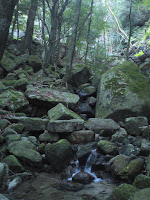
Much of the hike leads up the old stone path through evergreen deciduous forest. A thick canopy shades a dark, lush forest with a very open forest floor. However, the mature forest is broken up by plantation forests of young cryptomeria, and the contrast couldn't be more pronounced.
The details:
 |
| A sign at the gate. It's a beautiful trail, and there are a few mileage markers along the way, but don't expect any English :) |
Jomon Sugi is located. To get to the trail head, first head to the Comprehensive Nature Park, (総合自然公園, sougou shizen kouen. Park is a bit of a misnomer. It's mor like a nursery and gardens.) which is bike-riding distance from Miyanoura. There's a spacious field for parking by the river, or, if you're brave enough, you can drive 3.3km up the gravel road near the back of the parking lot. Then you'll arrive at a gate and you'll have to park the car next to the road. Continue another 1km by foot up the logging road to reach the official trail head. Altogether, from the gate to Ryujin Sugi and back is a 13 kilometer round trip with a map time of 8 to 9 hours.
 |
| Looking north from the logging road, you can see the mountains visited annually by pilgrims from the towns of Shitoko, Isso, and Yoshida. |
 |
| Stream crossing! |
There's no sign of giant trees until you near the end of the hike, but instead the trail weaves between beautifully matured broadleaf evergreen forest and young plantation forest. I've heard there may be plans to make the area more accessible, as it really is a beautiful forest even if you don't want to hike all the way to Ryujin, and evidence of logging communities brings the history to life.

| 
| 
|

 | ||
| The stone trail weaves between broadleaf evergreen forest and plantation forest. | ||

| 
| 
|
 | ||
| From top left: Fujin Sugi, a stump, Raijin Sugi, another stump. | ||
Once you get back to the parking lot at the Nature Park, there's a tiny public bath (heated spring water) called Yu no konoYu across the way. Because only several people can bathe at a time, it's a good idea to call in advance and make a reservation, but even if you don't have a reservation it's worth a try.
Destination Elevation: ~1260m
Trail Head Elevation: ~200m
Length: 13 km rouondtrip (including 2.2 km walking up the logging road beyond the gate)
Map time: 6~9 hours round trip for experienced hikers. Because there are so few people on the trail, I do not recommend it for inexperienced hikers.
Getting to the Trail Head: If you don't have a car, take a taxi from the town of Miyanoura. If you're really fit and you give yourself a couple extra hours to walk up the gravel road, you go as far as the Comprehensive Nature Park by bicycle.
Toilets: There are no toilets. There are usually not many hikers on this trail, but I still suggest you bring a disposable toilet pack (available at many shops and information booths in Yakushima).

No comments:
Post a Comment
Comments will be visible for five days before moderation. Please do not post a request for a hike as a comment