Tuesday, February 26, 2013

Exterior Mountain #1. Mocchomu-Dake


 Of all of Yakushima's Exterior Mountains, this is one of the most popular peaks. It's an intense uphill climb, and, tragically, weary hikers have gotten lost, but the rewards are plentiful.

 屋久島の前岳の一つ、モッチョム岳は最近、遭難事故があったが、モッチョム岳はかなり魅力的な山で、とっても人気です。この激しい登山を挑戦すれば、「洋上のアルプス」に一目惚れするでしょう。


Senpiro Falls
 The trail head is located next to the Senpiro Falls viewing area, in Yakushima's relatively sunny south. To see this waterfall is to understand the treacherous nature of Yakushima's geography. It's said that a group from mainland Japan was enjoying the river upstream, when they were caught in a storm and washed away while trying to cross. 

 登山口は屋久島の天気のいい(まぁ、北部に比べて、、)南部にある千尋の滝の展望台の近くに位置しています。とっても美しい滝です。普段は水量は少ないですが、屋久島の特徴である険しい花崗岩の斜面と川の危険がとてもわかりやすいです。上流で人が亡くなった例もあります。


If you've done a lot of hiking in Japan before, than you may be used to this sort of medium-maintenance trail. As with most hikes off the beaten path, you won't find any wooden staircases. Instead you'll be searching for trail markers (pink tape) as you go an navigating rocks, roots, and a couple streams. The terrain can be slippery and foggy. Get an early start so that nightfall doesn't catch you on this trail.

日本でハイキングの経験を富んでいる方は、こういうまま整備されている山道に慣れているかもしれませんが、屋久島のマイナーなルートとして、木製階段は一つでもありません。その代わりにピンクテープを探しながら、石、根っこ、沢渡みたいな障害物が多いです。雨の後、滑りやすくなって、霧も多いです。朝一でスタートして、暗くなる前に下山を終了しましょう。

Bandai Sugi
Taro
Between the first and second stream, it's a steep uphill climb. But two large Yakusugi, Bandai Sugi and Taro are waiting ahead. (If you feel warn out, know that the local kidergarten does an annual hike to Bandai Sugi!) Be careful not to injure the tree as you take a rest among the roots of Bandai Sugi.

一つ目も二つ目の沢の間は、かなり険しいクライムですが、その日本の屋久杉が待っています。それは、万代杉とモッチョム太郎と呼ばれています。麓の集落の幼稚園の子供たちは、毎年万代杉まで登っていますよ。あんまり疲れたら、根っこに傷をつけないように気をつけながら、万代杉で休憩しましょう。笑


Coptis Ramosa
Fill up your water bottle at the second stream, and the third one if it's flowing, because it's much dryer near the peak. Notice how the flora changes from mossy valleys and subtropical broadleaf species to conifers and even bamboo grass after you pass over the ridge and head down to the summit. Watch for coptis flowers in late winter, high-altitude rhododendrons in the late spring, and colorful insects in the summer. In the fall, keep an eye out for parasitic plants near the bottom. Oh, and don't overlook the bug-eating sundews in the parking lot! If you're lucky, you may stumble across an orchid in bloom, a piece of quartz, or a tribe of monkeys, but remember that this is part of the protected Natural World Heritage Site.

コケに覆われた谷に付き、おいしい水はありますし、どんどん登ると、植物の垂直分布はきれいに見えます。標高が高くなると、冬か春ならオウレン 、夏ならシャクナゲが咲いて、色とりどりの虫が飛びます。秋なら、標高の低い所で、寄生植物が見つけられるかもしれません。駐車場にも面白い植物がありますよ。それは、虫を食べるコモウセンゴケです。(本当の苔ではありません。)運が良ければ、ランの仲間、水晶、猿との出会いも可能ですが、この山道は世界遺産に含まれていますので、充分ご注意下さい。


Alas, the peak!
To visit Mocchomu-Dake, you should be in good physical shape. You'll be climbing over roots and rocks in one minute and holding on to them tight the next. To make it up the last few meters, you'll want your hands completely free to hoist yourself up a final rope. Bring a lunch, a water bottle, and a light jacket even in the summer. Depending on your cell phone carrier, you'll be within cell phone contact for most of the way, but especially if you don't have a cell phone, I suggest carrying even a minimal first aid kit and a whistle.

モッチョム岳を挑戦するのには、ある程度体力が必要です。根っこや岩が多く、手足を使いながら登ります。最後にロープを使って登るところ2ヶ所ぐらいあります。夏でも、軽いジャケットと、そうして弁当とお水を持参して下さい。携帯は会社によって、だいたい繋がりますが、基本の救急箱や笛の持参も進めます。
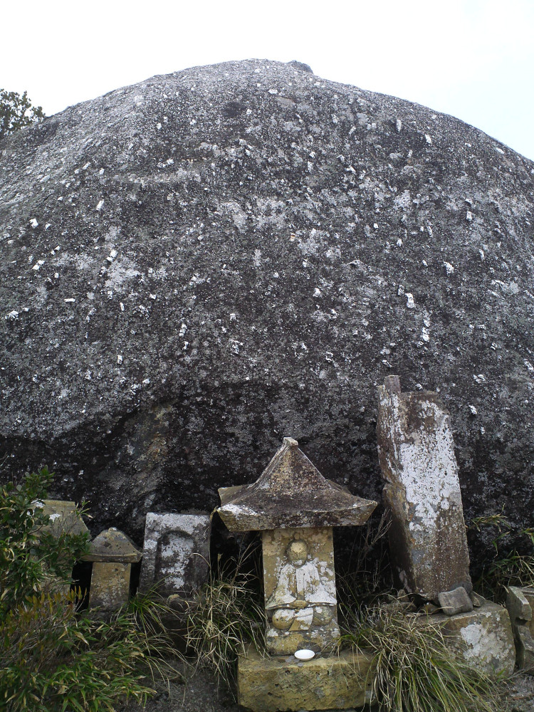


Shrine at the peak

The beauty of this mountain goes beyond its physical description. There's a certain peace to be had after visiting the small shrine and sitting on the rocks at the peak, looking out over southeastern Yakushima.

この山の独特の魅力は説明しにくいものです。祠を見つけ、山頂の岩の上に座りながら、屋久島の南東の山々や集落を見渡して、深い空間を楽しめます。


Peak Elevation: 940m
Trail Head Elevation: ~350m
Map time: 6+ hours round trip for people in top shape. 8+ hours is typical.
Bus stop: It's a long walk from the main road, but that doesn't stop people.

Saturday, December 29, 2012

Finding the Trail Head

There's plenty of human-erected treasures to search for on Yakushima:

Seven statues of the Fortune God. . . .Countless small shrines to Ebisu. . . .Village plaques. . . .Trail heads.

Yeh, trail heads.

I mentioned before on my facebook page that I'd like to visit all the mountain-peak shrines in Yakushima. Most of these are on the lower Exterior Mountains and require only a two to three hour hike from the trail head.

Finding the trail heads, however, is the real challenge. Beyond the major routes in books and tourist maps (i.e. the regularly-maintained trails to places like Mt. Miyanoura and Jomon Sugi, places that require nothing more than physical preparation), it's not obvious how many of these old trails are still in use, where they begin, and if whether or not they've just disappeared into the brush. To make matters ten times more complicated, it turns out even the latest maps of Yakushima have some number of phantom back-roads. And the roads that do exist may be half-washed away or blocked by gates for various reasons.

Through a mix of GPS, asking for directions, and trial and error, any day you find a new, legitimate trail head is a good day. Today was one of those days, and that's why I leave you with a picture of a (genuine, Yakushima) cow.

This is not the way to the trail head.

Thursday, December 13, 2012

Hananoego Trail: A deep forest trek


After hiking most of the other major trails, I finally did the less-popular Hananoego Trail last week. This is a gorgeous trail that meanders up and down for 8.4 km from the far end of the Yakusugiland Park, to Hananoego, the high-altitude peat marsh.

The trail splits off into the deep forest halfway along the 150-min Yakusugiland course. Almost immediately, I lose my sense of direction and begin to feel a vague sense of isolation. I remember reading somewhere that the Hananoego Trail was originally staked out for a national foot race, and, although I have my doubts about that, it certainly requires a bit of sweat and perseverance to follow this trail until it finally reaches a forest ridge walk. This is only major trail that has taken me nearly full map-time to walk (6-7 hours from the parking lot at Yakusugiland to Hananoego, where the Hananoego Trail meets the Yodogawa Trail. ).


Yamato Sugi
est. age: 3,000-4,000 yrs


About 90 minutes after leaving Yakusugiland, signs lead down a short path to Yamato Sugi. This cryptomeria is over 10 meters around, nearly 30 meters tall, and has an estimated age of 3,000-4,000 years.

Stream/River Crossing


There's one beautiful stream-crossing (a tributary of the Anbo River), so check for weather-warnings if you do this trail.

View from Mihirashi Observation Point.
Today, a band of clouds obscured the
peaks of the Interior Mountains.


Although this trail doesn't lead to a mountain peak, it does have one rocky outlook, which you can use a rope to climb up. This is the first spot where I was finally able to get a sense of location. You can see across to the highest Interior Mountains, and also "Tofu Rock" beyond Hananoego (not in my picture).

Ishizua Hut. They say it's haunted.

Finally, the trail leads to Ishizua Hut. This hut is very clean inside, and big enough to hold twenty people, although it's usually rather quite. Of course, there is a stream nearby for water, and a toilet, but at 1580 meters nights are cold, and some people say it's haunted. . .

Remains of a shelter at Hananoego.
Within an hour of leaving Ishizuka Hut, I reach Hananoego, one of my favorite places. There are the remains of an old, collapsed shelter, and a very welcoming bench . . .
Here, the trail ends, and I take the Yodogawa trail to get back to the road. The Yodogawa trail follows a short boardwalk through the Hananoego peat marsh before turning back into the forest. The peat is as old as 2,600 years, and there is often a variety of flowers depending on the season.


Beautiful Yodogawa River


The forest is thick with giant cryptomeria, fur, and spruce trees disappearing into the mist. A bridge crosses over the calm, emerald Yodogawa River just before the spacious Yodogawa Hut (much more popular than the Ishzuka Hut!), and I know my hike is almost over . . .


. . . Except that when I reach the Yodogawa Trailhead I still have 7.5km of asphalt between me and my car. But at least it's downhill!

I think that return route down the asphalt street is main turn-off of the Hananoego Trail, but this trail is really too long to do a round-trip in a day without following the street back, and too short to split into two days.

So, I guess the Hananoego Trail is best for folks who want a good, long, rough hike through the woods, because this trail is just as demanding as hiking to a mountain peak, except that there's no peak to look forward to. Also, it's not entirely impossible to get lost on this trail, since it sees so little traffic. But, as one of several routes to Hananoego, it can serve as a gateway to the Interior Mountains, and if you're looking for more moss than people, this is a beautiful route!


Thursday, November 29, 2012

Allure of the Exterior Mountains

Gazing out from Mt. Ishidzuka
Just as hiking the Interior Mountains is an awesome experience, hiking the Exterior Mountains is a humbling experience.

Traditionally, Yakushima's mountains are divided into the Interior Mountains (Called the Oku-dake, these include the highest peaks.) and the Exterior mountains. (Called the Mae-dake, these mountains hide the Oku-dake from sight of the coastal towns.) In the past, islanders visited the Mae-dake quite frequently, but rarely approached the Oku-dake. The Oku-dake were considered the sacred realm of the gods, peaks for a select few pilgrims to visit annually. Daily needs for wood and forest products were filled from the Mae-dake.

Interior Mountains viewed
from Aiko-dake

View from Taiko Iwa . . .
bit obscured by clouds, but try
Googling images of Taiko Iwa.

Mae-dake seen from
across the valley
And then came the logging boom.

And then the tourism boom.

Now, I think, the pattern is reversed. The trails across the Oku-dake--including Mt. Miyanoura (Kyushu's highest peak), Mt. Kurio, Kuromi-Dake and a few other peaks--are well maintained and easy to follow, with wooden boards and ropes where needed. Popular trails can see hundreds of people a day.

But not so many people visit the Mae-dake. I suppose that although the trails are rougher, they just don't make for good boasting stories. The intense trail up Mt. Mocchomu. The treacherous trail up Aiko-dake. And the allure is a bit more subtle than the "360-degree ocean view" offered by Mt. Miyanoura.

Personally, though, I don't think it's possible to appreciate the grandeur of the Oku-dake without stepping back. Visitors to Shiratani-Unsuikyo's lookout from Taiko Iwa will understand what I mean. To stand on one of the eastern Mae-dake peaks and gaze across the valley at the magnificent Oku-dake is truly a humbling experience.
As if you've jumped into the middle of a deep and vast ocean, you feel incredibly small.

This sensation is ridiculously hard to capture in a picture, but if you fancy experiencing it firsthand, check the weather and do a little homework first: Not all of the Mae-dake offer views of the Oku-dake, and some clouds and fog can cover up the splendor from any peak. Also, despite being lower than the Oku-dake, they can be just as (or more!) dangerous. Taiko Iwa in Shiratani-Unsuikyo is probably the easiest way to enjoy the view I'm talking about, and--since it's located well into the interior of the island--experienced hikers can continue on to access the Oku-dake trails directly from Shiratani.

With a little help from the weather, the view of Mt. Miyanoura can be every bit as moving as the view from Mt. Miyanoura.